Related Posts Plugin for WordPress, Blogger...
Showing posts with label Western Australia. Show all posts

Friday, January 27, 2012

In photos: Kalbarri coastline and national park

{EAV:4965e67f495e370c}

Australia has a lot of coastline – nearly 26,000km of the stuff, according to the CIA world fact book. Driving that distance in a straight line would take you half way around the world.

Quite a lot of this coastline is spectacular. Today I’m highlighting the coastline around Kalbarri, which is about half way down the Western Australia coast, just north of Geraldton.

This stretch of coastline is reminiscent of Victora’s Great Ocean Road – and in fact, when I posted a sneak preview of these shots on my facebook page many commentators thought that this was that famous stretch of coastline.

Unlike the Great Ocean Road though, this bit of coastline is less trafficked and more isolated. As well as the coastline, there is also a beautiful interior national park featuring stunning bush scenery, gorges, and rock formations, which is worth spending some time exploring. On now, to the photos!

Beach and headland Kalbarri

The beaches are home to some pretty epic waves. Surfing is big round here!

Kalbarri coastline beach sand

Where the rocks give way to sand, looking north along the coast.

More cliffs

It is a bit like that ocean road!

Waves carshing on the coastline of Kalbarri Western Australia

The waves discourage casual swimming.

kalbarri national park western australia

And this is the inland bit of the national park

Looking through the archway Kalbarri national park

Looking through the arch rock up the gorge

That was Kalbarri and surrounds in photos! Have you visited? There is plenty of exploring to do, and the town of Kalbarri makes a good base. As well as just seeing the sights, there are a whole bunch of walks that can be done, both along the coast and in the bush wilderness. You can get more information on this park, and lots of other WA parks, at the DEC site.

Wednesday, January 18, 2012

In photos: Wolfe Creek Meteor Crater

Wolfe Creek Meteor Crater

Out in Western Australia’s remote outback is the quite remarkable Wolfe Creek Meteor Crater. This was formed as a result of 50,000 tonnes of rock (think large battleship size) crashing into the earth around 300,000 years ago.

Made infamous as a result of a 2005 horror film, the crater is an incredible sight, set in truly stunning outback scenery. It isn’t that accessible, and you’re going to want a 4WD vehicle ideally to get out there, but the wilderness you will find is totally worth the effort.

Today’s photos will hopefully give you a glimpse of what is out here, in the middle of Australia’s incredible outback next to an ancient 800 metre wide meteor crater.

Wolfe Creek Meteor Crater sign.png

The sign. In case you’d driven 800km by mistake.

Australian outback

The surrounding outback from the crater rim. Hills do not feature heavily.

Outback sunset from crater rim.png

Sunset from the crater rim. This place is both spectacular and deserted.

Wolfe Creek Crater

Looking into the 800m wide crater. You can walk around it, which takes just under an hour, and walk into it, which takes less time.

Wolfe Creek Crater Panorama

A panorama of the crater just after sunset.

Outback sunset Australia

And finally: the kind of sunset view that reminds me how awesome life is. The stars at night are pretty damn spectacular out here too – light pollution not featuring heavily!

So that’s the Wolfe Creek Meteor Crater. I’d recommend spending a couple of days out here just to soak it all in (and make the journey worth it!). And while you’re in WA, you should check out some of the other incredible highlights this state has to offer.

Thursday, December 2, 2010

Offroad in Oz: The Gibb River Road

Gibb River Road with Cockburn mountain backdrop I thought it was about time to revisit a series I started a while ago looking at some of the great offroad adventures you can have in Australia. Today I’ll be talking about the Gibb River Road, perhaps one of Australia’s most famous outback four wheel drive routes.

First things first. Whilst iconic - and certainly four wheel drive only - apart from a few sections this isn’t a particularly challenging four wheel drive route. So if you were hoping for hill climbs, boulders, or seriously way off the map isolation, you may be better off looking at something like Gregory National Park or the Canning Stock Route to give yourself a serious 4WD challenge.

If on the other hand you were thinking more about scenic gorges, endless croc free (mostly!) rockpools to bathe in and just enough of a four wheel drive adventure to make your trip that bit more exciting, then the Gibb River Road is for you.
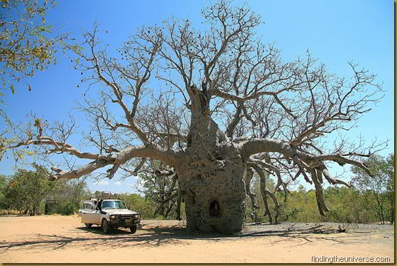
Prison Boab Tree on the Gibb River Road

Set in the northern half of Western Australia, and cutting across the jaw droppingly beautiful Kimberley region, this is one trip that absolutely must be on the list for anyone with the right sort of wheels travelling through this area. The route starts (or finishes, depending on your mood) at the town of Derby and then runs for nearly 660 largely unsealed and glorious kilometres to the tarmac of the great northern highway, between the towns of Wyndham and Kununarra.

Like so many of Australia’s legendary outback tracks, the road was initially built as a cattle route, to transport cattle from farm to market. It is deep in Western Australia’s tropics, so it’s best to tackle the road during the dry season, as in the wet the three main river crossings become largely impassable, and large sections of the road are liable to be either flooded or washed out.

We took the trip starting at the Wyndham end of the route. It’s worth dropping in to Wyndham if only to drive up to the top of the lookout where you can see no less than five rivers converging to merge into the sea. An amazing view, with the Cockburn ranges providing a tremendous backdrop. Sunset is a great time to take this in.

From Wyndham the road winds it’s way past the Cockburn ranges, and here you have a choice of a fairly easy gravel road or a far more exciting (if time consuming) sand filled Mitchell Falls - Kalumburu and Gibb River Road - Western Australiatrack, before the first river crossing in this direction, the Pentecost. In the dry season, this is an easy (if wide) shallow crossing where the water is unlikely to get more than 10-20cm deep.

From the Pentecost river the road continues through beautiful scenery, all the way to the junction with the Kalumburu road. This is an optional side track which takes you all the way to the northern coastline, to the four tiered waterfall known as Mitchell Falls and the aboriginal community of Kalumburu. The latter requires a permit for visitation and has a no alcohol policy.  If you decide to do the side trip, and I would highly recommend it for the waterfall alone, which is a magnificent sight as it carves its way over four ledges via a series of glorious lakes, then be prepared for a fair amount of additional driving. From the turn off to the Drysdale Station is around 60km, and from there to the Mitchell Falls is a further 188km, the last section of which can be a bit tricky and has claimed a few vehicles. Fuel on this side route is only available at either the Drysdale Station or Kalumburu, although if you can, take fuel with you because it is really quite expensive along the whole route due to the isolation.

After the side trip to Mitchell Falls and Kalumburu is where the journey really starts to get interesting. Along the road there are multiple beautiful gorges that can be explored, most of which have rock holes that are croc free and safe to swim in (although if in doubt, don’t enter the water). Highlights of the route Bell Gorge waterfall - Gibb River Road - Western Australiainclude the Mount Barnett campsite, which has two swimming options – one a long stretch of water just next to the camp with free inner tubes to bob around on, another a short hike through the bush to Manning Gorge - a stunning rock pool and waterfall. Definitely worth the walk. You could probably spend days just in this spot alone.

From Mount Barnett, the road takes you past a number of other wonderful spots, including Galvans Gorge and Adcock Gorge, before you arrive at another unmissable spot – Bell Gorge. This requires another short walk, although camping is available nearby, to a river which drops away over a multi-tiered waterfall into another gorgeous swimming spot. When you spend as much time driving on dusty roads as the Gibb River demands, these spots really are heavenly relief, and you could spend some serious time here doing very little.

From Bell Gorge the road takes you on to Lennard Gorge (gorges are a serious drawcard of this drive, as you may have guessed), before splitting and giving you an option. You can continue on to Derby, via a bit of dirt road and then bitumen, or you can turn south towards the Great Northern Highway, and go to Windjana Gorge and Tunnel Creek. I cannot recommend doing this enough. Windjana Gorge - Gibb River Road - Western Australia
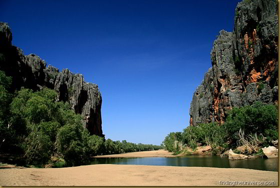
Windjana Gorge is where a river cuts its way through a 360 million year old Devonian reef, which due to the wonders of geology, has now found itself deep in the Australian outback. It rises out of the surrounding flatlands, an imposing black cliff, straight out of a science fiction movie, with the gorge running through its centre. It is home to a large population of freshwater crocodiles, and has played host to some remarkable fossil finds, which are embedded in the reef. A walk from one end of the gorge to the other, past hordes of bats hanging upside down in the trees and fossilised Devonian era creatures in the cliff face, is a must.

Close encounters of the rock art kind A little further south from this spot is Tunnel Creek, a kilometre long tunnel which cuts underneath the reef, which can be explored on foot. It is dark, full of bats, and some parts will require you to wade, so bring a torch and go in clothes you don’t mind getting wet. A tremendous way to end your Gibb River Road adventure.

In terms of preparing for the trip, you need to be largely self sufficient as there are very limited supplies on the route. Fuel is available at Mount Barnett, Imintji Roadhouse and Drysdale Station, as well as at the top at Kalumburu. Don’t rely on both petrol and diesel being available everywhere though, and expect it to be expensive everywhere – getting fuel to these remote locations isn’t cheap. The only store on the main road is at Mount Barnett, and as always, you should be carrying enough food and water to last you should you be unfortunate enough to break down. Recovery options are limited and expensive on this road, so be as prepared as you can to sort yourself out (two spare tyres, recovery equipment, etc..).

Accommodation options are also fairly limited. Free camping along the way isn’t that easy to find as much of the land is privately owned. There are some national park campsites at spots like Mitchell Falls, Bell Gorge and Windjana Gorge, otherwise you will be at privately owned sites like El Questro, Barnett River and Drysdale River. Whilst not overly expensive, do expect to pay a little bit more at these spots than you would elsewhere in Western Australia. My advice would be to just suck it up and pay because it is absolutely worth it.
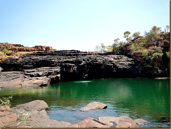
Manning Gorge - Gibb River Road - Western Australia

If you enjoyed this post, you may want to look at the others in the series, where I looked at going offroad in Australia’s Gregory National Park and Limmen National Park. I also did a full article on preparing for an offroad trip, as well as other ideas for things to do whilst in Western Australia. Enjoy!

Friday, September 24, 2010

Blowholes and pinnacles – more of WA

Wave crashing at sunset - Western Australia - Australia - Square I did a post recently on my highlights of Western Australia, where I covered my four favourite spots in Western Australia.

Unfortunately, after much thinking, I have concluded that it’s just too much of an amazing place to be happy with only highlighting four spots.

Here, therefore, are four more spots that you should try and take the time to visit if you are lucky enough to have time to spare in this amazing state.

From desert to water, and mountains to sealife – you won’t run out of things to do in WA!


The Pinnacles Desert

Where? Near Cervantes, 231km NW of Perth
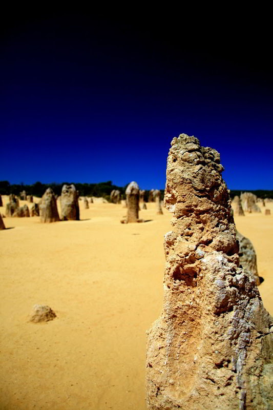
Why? The Pinnacles are a series of weird limestone rock formations poking out of the desert sand, much like the fossilised fingers of some giant underground desert dwelling animal. Interestingly there is no agreed upon geographical explanation for their formation, with at least three competing theories vying for prominence. 

Pinnacles Desert 1 - Western Australia - Australia

What can be agreed upon is that the rocks are absolutely spectacular. Jutting out of the fine desert sand, the contrast of the limestone against the immense blue of the Australian sky is incredible. You will find yourself wandering around the area, mesmerised, taking photo after photo.

The best time to visit is during Spring (August – October), when the temperatures are not so high and the wildflowers are starting to flower. Early morning or late afternoon provides the best light, when the shadows of the rocks play out across the sand.

Carnarvon Blowholes

Where? 75km N of Carnarvon, approx 1000km N of Perth
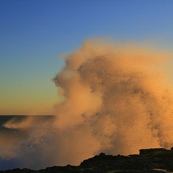
Why? This stretch of the Western Australian coastline is host to jagged rocky coastline   and massive, angry seas. Whilst this is not ideal for swimming or surfing, it is perfect for being impressed by the power of nature, as waves crash relentlessly against the seemingly unyielding shore.

BlowholenearCarnarvonWesternAustrali[2]

The blowholes, just north of Carnarvon, form a spectacular sight as water is forced through holes in the rock to explode in a plume that can reach over twenty metres in height.

Just a kilometre or so from the blowholes is a cheap camping spot on a sheltered cove with safe snorkelling in the lagoon and a beautiful white sandy beach to wander along. Folk come here for a while to stay, and there are a number of semi-permanent tin shelters which give the impression that you have found a post-apocalyptic village. Absolutely worth a visit.

Francois Peron National Park

Where? Shark Bay World Heritage Area, Peron Peninsula, approx 700km N of Perth
Why? Shark Bay is a giant bay formed by four peninsulas jutting off the Western  Australian coastline into the Indian Ocean, the largest of which is the Peron peninsula. The northern end of the peninsula is given over to the Francois Peron National Park, which is a must-see for fans of striking contrasts, wilderness and marine life.

DugongswimminginthewatersofSharkBayW[2]

Here, red sand dunes meet white sandy beaches and the sparkling turquoise waters of the Indian Ocean. There is excellent snorkelling, bushwalking and wildlife viewing, particularly of the marine sort. At Cape Peron, for example, you can stand on the viewing platforms and look down at the fabulously clear and shallow waters, where manta rays, turtles, sharks and dolphins will cruise on by. Shark Bay is also home to the almost mythical dugong – oft mistaken for mermaids by sailors in times gone by. Presumably after many tipples of rum. 10% of the world’s population of dugong lives in Shark Bay, feeding off the massive seagrass meadows which are found here.

Beach camping is an excellent option in this park, which is four wheel drive only due to the sandy tracks. There is also, most bizarrely, a free hot tub at the park entrance, which is fed by geothermal springs. Finally, if you are in the Shark Bay area already, you would do worse than to visit the stromatolites of Hamelin Pool – one of the only places in the world where you can see a living example of the organisms that created the oxygen in our atmosphere nearly three and a half billion years ago.

Kennedy Ranges National Park

Where? 150km east of Carnarvon, aprox. 1100km N of Perth.
Why? The Kennedy Ranges are not exactly on the radar as a must-visit site when  cruising around Australia, which is a bit of a shame. They are, certainly, a bit out of the way, involving a fair amount of driving on dirt roads to get to, but they are absolutely worth it.

HoneycombGorgeKennedyRangesWesternAu

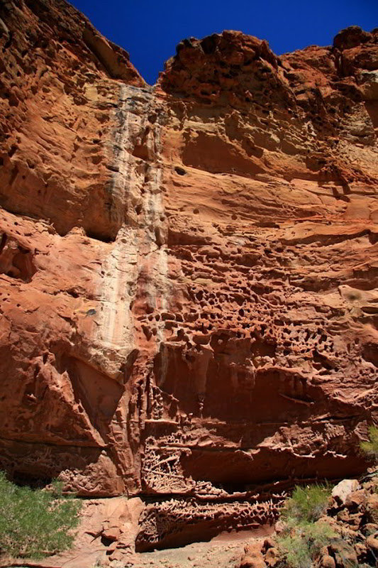
The Kennedy Ranges are a 195km long mesa which rises entirely unexpectedly out of the surrounding flat land as a cliff face which, at points, is over a hundred metres high. On top of the mesa are 15,000 year old red sand dunes, which sit atop this remnant of an ancient land surface. Numerous gorges lead into the mesa, with stunning rock formations rising to either side as you explore and scramble along the loosely defined paths. The most impressive of these are at the Honeycomb Gorge, where the rock has eroded away to form surreal shapes, as if some giant beehive was once in existence here.

Trails lead to the top of the mesa, as well as down a number of the gorges. The views from the top across the outback wilderness are stunning, and well worth the climb. Sitting at the base with a cold beer as the sun sets is an unforgettable experience. Basic camping facilities are available at the foot of the mesa, to fully appreciate the place I’d recommend staying at least a night, if not more.

If you are in the area you could also visit Mount Augustus, the worlds largest monolith (twice the size of Australia’s somewhat more famous monolith, Uluru), which is about another 300km drive inland.

So. Another four tremendous spots in Western Australia, and I still haven’t covered it all. If you liked this, you will probably enjoy reading about the previous four spots I highlighted, or the article about art on a salt lake, far away from anywhere.

Friday, September 17, 2010

Unmissable Western Australia

Bungle Bungles, WA

Western Australia. A state so big and varied that you could easily mistake it for a country in its own right. From the giant trees of the south, to the harsh desert of the centre, to the rugged coastline and wilderness of the north, and finally to the cosmopolitan delights of Perth, there is something here for everyone.

I have picked my four favourite spots in this wonderful state, each offering something different. It was tough to come up with only four, but after much brow furrowing, here they are:

Purnululu National Park - the “Bungle Bungles”

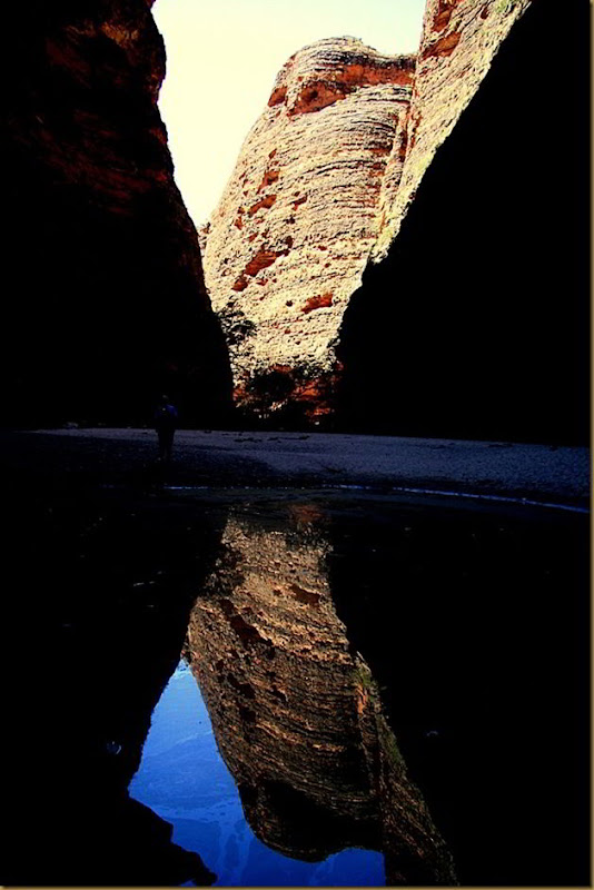
View from inside Cathedral Gorge, Bungle Bungles

Where? In the north eastern corner of WA, 250km south of Kununurra
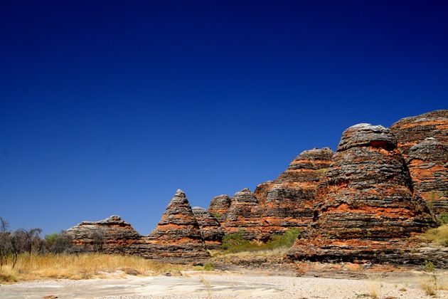
Why? The world heritage listed Purnululu National Park in the Kimberley region of WA is home to the absolutely staggering sandstone formation known as the Bungle Bungles. These are a series of improbably striped orange and grey rocks, towering as much as 580 metres above sea level.

There are domes to wander around, cones to goggle at and chasms to explore. It is a seriously surreal landscape, with the orange and grey rocks set against the deep blue of the outback sky. Truly unmissable.

If you are in the Bungle Bungle area with a bit of time in your hands, you may also want to pop a few hundred kilometres further south and visit the Wolfe Creek meteor crater. Made famous by the horror film, this 875 metre wide crater is worth a visit in its own right.

You can wander the rim, walk down to the crater bed, and wonder as to the immensity of 50,000 tonnes of rock hitting the earth at phenomenal speed.

The southern forests of Western Australia

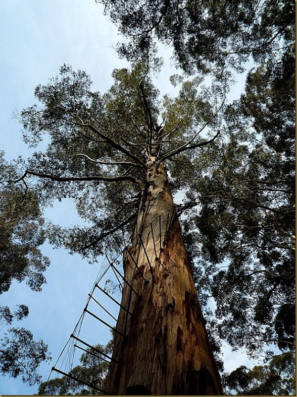
One of the fire trees in Western Australia. Climb it - if you dare

Where? South Western Australia, around 300km south of Perth
Why? The majesty of the forests with their towering giants is in stark contrast to the outback wildernesses of much of the rest of the state. You can walk amongst these huge trees and drink in the peace of their majesty whilst marvelling at their stature - these are some of the largest examples of trees of their type in the world.

If that all sounds a bit too relaxing and in touch with mother nature for you, you can throw all caution to the wind and climb one of the three fire trees, a challenge fit only for the truly insane with a good head for heights.

The fire trees were established in the 1930’s as a means to quickly detect forest fires. They consist of a simple platform at the top of a seriously high tree, the highest being the platform at the top of the Dave Evans Bicentennial tree, at 68 metres above ground.

The way up these trees is a series of giant metal pegs which are hammered into the tree to form a heart-stoppingly scary spiral stair case. There are no safety features, no floor, and nothing to stop you, other than a sign warning you that you climb at your own risk. I made it to about 25 metres up and the first “breather” platform before, body shaking, I retreated to ground level and safety. Good luck!

The Stirling Ranges

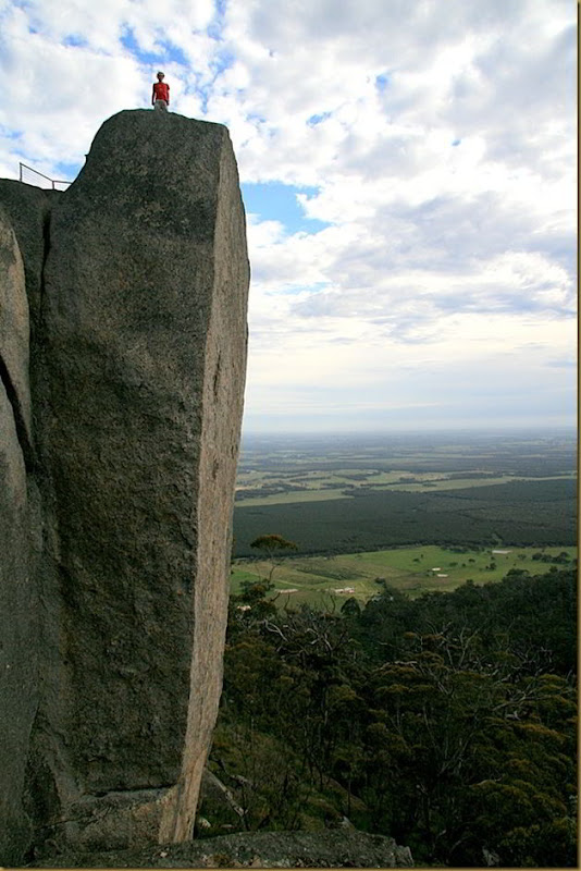
The Castle Rock in the Porongorup Ranges, Western Australia

Where? 337km south west of Perth
Why? If you love hiking and stunning mountain scenery, the compact Sterling ranges are for you. Whilst perhaps not as alpine like (or as high!) as the Victorian Alps, the Stirling Ranges offer some fabulous and easily accessible hiking opportunities.

So much so, in fact, that one of the walks, up Mt. Toolbronup, made the list of my top three day hikes in Australia. As you would expect, the walks are fabulous. Some, like the climb up Bluff Knoll, the highest peak for 1000km in any direction, are pretty tough, but the views from the top are absolutely worth it.

Also in the area is the Porongorup range, a series of peaks formed over 1.2 billion years ago. These offer slightly easier walking options than the Stirling ranges, with the added bonus that you can see the entire Stirling ranges from their peaks, a dramatic silhouette.

The Castle Rock is a highlight here, an incredibly tall chunk of boulder, accessed via a series of fairly scary ladders and stairs, with a rewarding view from the top if you make it!

Ningaloo Reef

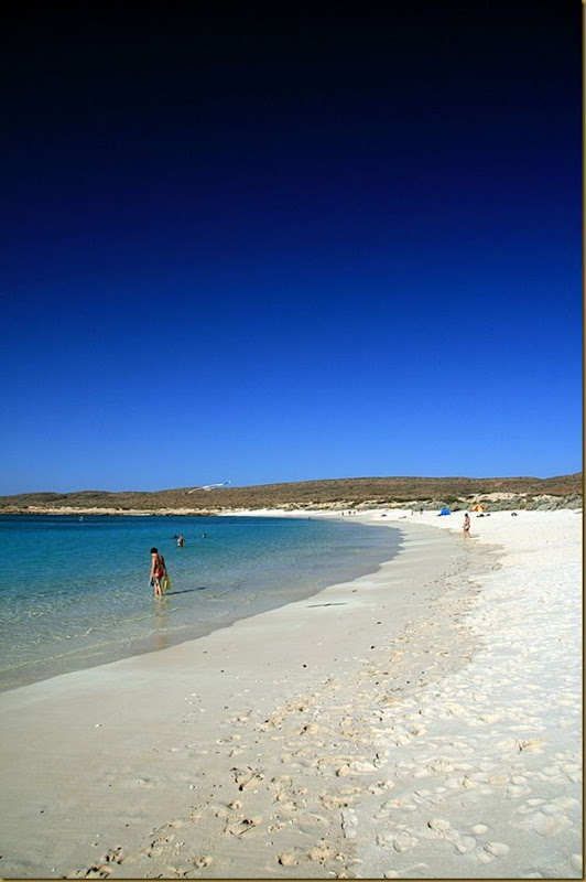
Beach of Turquoise Bay, Ningaloo Reef, Western Australia

Where? The north western tip of WA, near Exmouth
Why? Ningaloo is the worlds only large reef located practically on the beach. At its closest  point, it is a mere one hundred metres from the beach.

Unlike Australia’s other famous reef, which requires some serious boat time to access, you can literally wade into the sea and be getting up close and personal with the marine life in minutes. And the marine life is quite staggering. Turtles, rays and exotic fish will vie with over 250 species of spectacular coral for your attention.

There are a number of highlights along it’s 300km stretch. One of my favourite spots is Turquoise Bay, where you swim out then allow the current to drift you along parallel to the shore to the sand bar at the end, where you can get out, walk back along the beach and start again. Snorkelling without the effort! Does it get any better that? And if snorkelling doesn’t float your boat, then visit anyway for either the whale shark migration or the humpback whales breaching in the bay. It’s a sight you’ll never forget.

Well. What an amazing state. Marine life, beaches, forests, mountains and outback. Western Australia really has it all. And I’ve only scratched the surface. There’s the Gibb River Road, the gorges of Karijini National Park, the trains of Port Hedland (seven kilometre long trains have to be seen to be believed!), the dolphins of Monkey Mia.. the list goes on. There’s even art on a salt lake! If you’re visiting Australia, I urge you to take some time and visit this state. I promise you won’t regret it.

 
Bloggers - Meet Millions of Bloggers